Introduction
AirPath is a high-performance 3D aerial pathfinding solution for Unity, built on Unity's Data-Oriented Technology Stack (DOTS). It enables flying agents like drones, birds, aircraft, and other aerial units to navigate complex 3D environments while respecting terrain height and optimizing flight paths.
What is AirPath?
Unlike traditional 2D pathfinding solutions, AirPath calculates paths in three dimensions, taking terrain elevation into account. The system uses a height-aware A* algorithm that considers not just horizontal distance, but also the cost of flying at different altitudes, climbing, and navigating slopes.
AirPath is designed for scenarios where you need:
- Aerial navigation: Drones, birds, helicopters, or any flying agents
- Terrain-aware pathing: Routes that consider mountains, valleys, and elevation changes
- High performance: Burst-compiled jobs that run on multiple threads
- Swarm behavior: Coordinated movement of multiple agents along calculated paths
Key Features
Performance-First Architecture
AirPath leverages Unity's Job System and Burst compiler for maximum performance. The core A* algorithm runs as a Burst-compiled job, allowing pathfinding calculations to happen off the main thread without blocking your game.
Height-Aware Pathfinding
The pathfinding algorithm uses a multi-factor cost model that considers:
- Base movement distance
- Absolute altitude (higher = more costly)
- Climbing penalty (gaining altitude costs extra)
- Slope steepness (rapid height changes are penalized)
This produces natural-looking flight paths that prefer valleys and gradual climbs over direct mountain crossings.
Flexible Height Provider System
AirPath doesn't lock you into Unity Terrain. The IHeightProvider interface allows you to integrate any height data source — procedural terrain, mesh-based landscapes, voxel worlds, or custom data structures.
ScriptableObject Configuration
All settings are managed through ScriptableObject assets, making it easy to create presets, swap configurations at runtime, and keep your scenes clean.
Event-Driven Architecture
AirPath communicates through a robust event system, allowing loose coupling between components. Subscribe to path calculations, mode changes, and swarm updates without tight dependencies.
How It Works
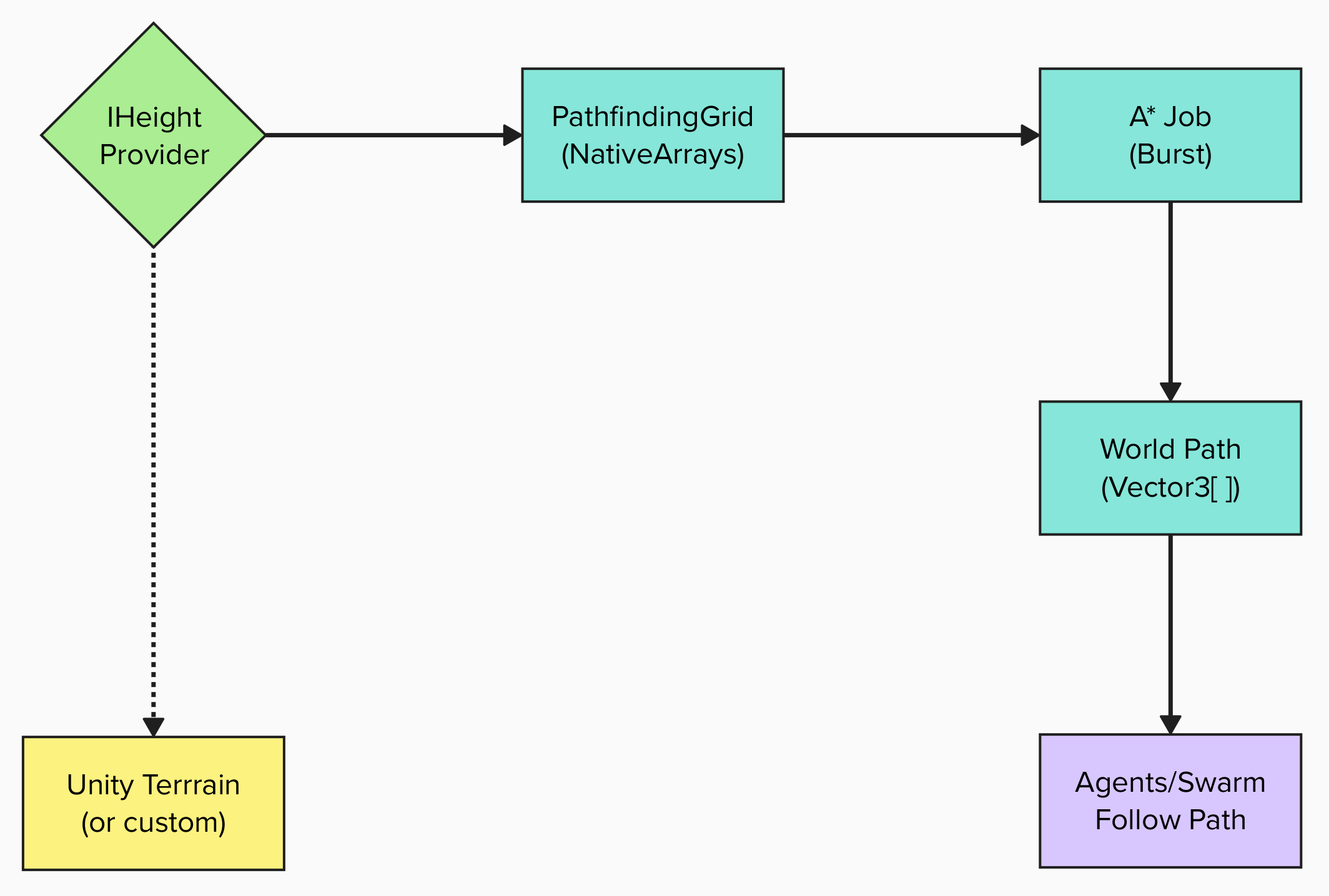
- Height Provider samples terrain elevation data into a grid
- PathfindingGrid stores this data in Burst-compatible NativeArrays
- A Star Job calculates the optimal path considering height costs
- World Path is returned as a list of 3D positions
- Agents follow the calculated path with optional smoothing
When to Use AirPath
AirPath is ideal for:
- Flight simulators with terrain following
- Drone simulation and visualization
- RTS games with air units
- Nature simulations with flocking birds
- Any game requiring intelligent aerial navigation
AirPath may not be the best fit if:
- You only need 2D ground-based pathfinding (use Unity NavMesh)
- Your agents don't need to consider terrain height
- You're targeting platforms without Burst support
Next Steps
Ready to get started? Head to the Requirements page to check compatibility, then follow the Installation guide to add AirPath to your project.